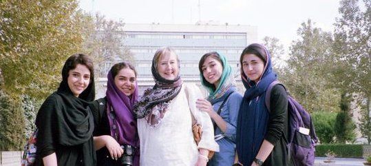
Liście światowego dziedzictwa UNESCO w Iranie
A World Heritage Site to miejsce (na przykład, budynek, miasto, kompleks, pustynie, lasy, wyspa, jezioro, pomnik lub góry), który jest wg tej Narodów Zjednoczonych dla Wychowania, Nauki i Kultury (UNESCO) jako mające szczególne znaczenie kulturowe lub fizycznej. Lista ta jest utrzymywana przez Międzynarodowy Program Światowego Dziedzictwa pod nadzorem UNESCO Komitetu Światowego Dziedzictwa, która składa się z 21 państw członkowskich UNESCO, wybieranych przez Walne Zgromadzenie.
Katalogi programów, nazwy i przechowuje obiekty, które mają wielką kulturową lub fizyczną wagę do wspólnego dziedzictwa ludzkości. W pewnych warunkach, wymienione strony mogą uzyskiwać środki finansowe z Funduszu Dziedzictwa Światowego. Program powstał z Konwencji w sprawie dziedzictwa kulturalnego i naturalnego na świecie, który został przyjęty przez Konferencję Generalną UNESCO w dniu 16 listopada 1972 r. Od tego czasu 191 Państwa-Strony ratyfikowało konwencję, co czyni go jednym z najczęściej używanych instrumentów międzynarodowych. Liechtenstein, Nauru, Somalia, Sudan Południowy, Timor Wschodni i Tuvalu nie są stronami konwencji.
Listę zidentyfikował 21 obiektów w Iranie na Listę Światowego Dziedzictwa.
- Ormiański klasztorne Zespoły Iranu
- Bam i jego krajobraz kulturowy
- Bisotun
- Krajobraz kulturowy Maymanda
- Gonbad-e-Q¯ab¯us
- Pałac golestan
- Masjid-e Jame Isfahanu
- Meidan Emam, Esfahan
- Pasargady
- Persepolis
- Shahr-Sohta
- Sheikh Safi al-Din Khanega i Świątynia Ensemble
- Historyczny Układ hydrauliczny Shushtar
- Soltaniyeh
- Susa
- Historyczny Bazar w Tabriz
- Takht-e-Soleiman
- Czoga zanbil
- Perski ogród (Eram Garden)
- Irański Rope (lina)
- LUT Desert (Kavir LUT)
Miejsce dziedzictwa światowego UNESCO | 2008
Ormiański klasztorne Zespoły Iranu
Ormiański klasztorne Zespoły Iranu w północno-zachodniej części kraju, składa się z trzech zespołów klasztornych ormiańskiej wiary chrześcijańskiej św Tadeusza, Świętego Stefana i kaplic Dzorzora. Te budynki -., Z których najstarszy, St Tadeusz, należą do VII wieku - to przykłady wyjątkowej uniwersalnej wartości ormiańskiej tradycji architektonicznych i dekoracyjnych. Wykazują one bardzo ważne wymiany z innymi kulturami regionalnymi, w szczególności bizantyjskiej, prawosławnych i perskim. Klasztory, położone na południowo-wschodnich obrzeżach głównej strefy ormiańskiego przestrzeni kulturowej, jest głównym ośrodkiem rozpowszechniania tej kultury w regionie.
Miejsce dziedzictwa światowego UNESCO | 2004
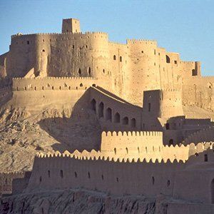
Bam i jego krajobraz kulturowy
Bam leży w środowisku pustynnym na południowym skraju płaskowyżu irańskiego. pochodzenie bam można przypisać do okresu Achaemenides (VI IV ml. BC. E.). Jej powodzenie nauczył się od 7 do 11 wieku, będąc na skrzyżowaniu ważnych szlaków handlowych i znana z produkcji jedwabiu i bawełny odzieży. Istnienie życia w oazie była oparta na podziemnych kanałów nawadniających, lin, z których Bam zachował jedne z najwcześniejszych dowodów w Iranie. Arg-e Bam jest najbardziej reprezentatywnym przykładem ufortyfikowanego średniowiecznego miasta zbudowanego w tradycyjny sposób za pomocą warstwy błota (Chineh).
Miejsce dziedzictwa światowego UNESCO | 2006
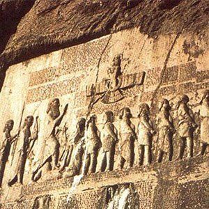
Bisotun
Bisotun znajduje się wzdłuż starożytnego szlaku handlowego łączącego irańskiego płaskowyż z Mezopotamii i ma pozostałości z czasów prehistorycznych do środkowej, Achemenidów, Sassanian i okresów ilhanidskogo. Głównym zabytkiem tej archeologicznego jest płaskorzeźba i klinowym napis zamawiane przez Dariusza I, wielki, kiedy wstąpił na tron imperium perskiego, 521 pne. Płaskorzeźba przedstawia Darius trzyma łuk, jako znak suwerenności i kroczenie na rysunku klatki piersiowej, która leży na plecach w porę. Według legendy, oznacza postać Gaumata, mediana i MAGE wnioskodawcy tron, co spowodowało zabicia przybycia mocy Dariusz.
Miejsce dziedzictwa światowego UNESCO | 2015
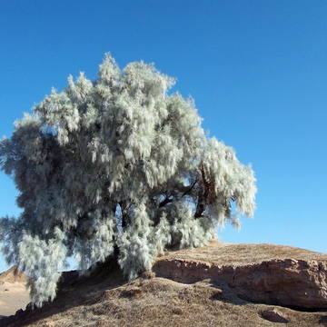
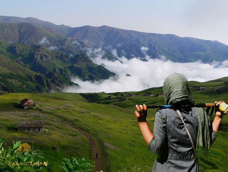
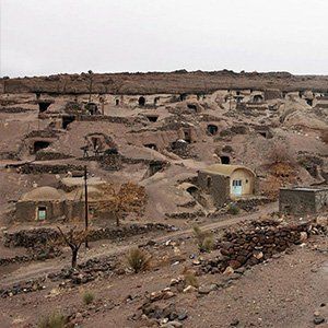
Krajobraz kulturowy Maymand
Maymand - an autonomiczne półpustynne obszary doliny na południowym krańcu górach centralnej Iranie. Wieśniacy - pół-koczowniczy pasterzy-rolników. Rosną swoje zwierzęta na pastwiskach górskich, mieszka w tymczasowych osiedlach na wiosnę i jesienią. W miesiącach zimowych żyją w dolinie poniżej groty wykute w miękkiej skale (Kumar), nietypowym kształcie obudowy w środowisku suchym pustyni. Ten krajobraz kulturowy jest przykładem systemu, który wydaje się być bardziej powszechne w przeszłości i obejmuje przepływ ludzi, a nie zwierząt.
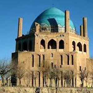
Miejsce dziedzictwa światowego UNESCO | 2012
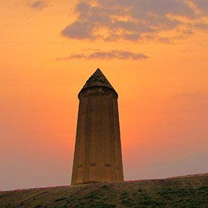
Grobowiec w Gonbad-e Kawus
Wysokość wysokość grób 53 m, zbudowany w 1006 roku dla Qaboos Ibn Voshmgira, linijka i pisarze ziyarid dynastię, w pobliżu ruin starożytnego miasta w północno-wschodnim Iranie Dzhordzhana, dowody wymiany kulturalnej między nomadami Azji Środkowej i starożytnych cywilizacji irańskiej, Wieża jest jedynym zachowanym dowodem Yorgana, dawnego centrum Sztuki i Nauki, który został zniszczony w czasie najazdu Mongołów w XIV i XV wieku. Jest to wyjątkowa i innowacyjna technologicznie przykładem architektury islamskiej, który wpłynął budowla sakralna w Iranie, Anatolii i Azji Środkowej. Zbudowane z cegieł nieszkliwione pieczonych złożone geometrie Monument zwężają średnica cylindra 17-15,5 m, zakończonego stożkowo cegły dachu. To ilustruje rozwój matematyki i nauki w świecie muzułmańskim na przełomie pierwszego tysiąclecia naszej ery.
Miejsce dziedzictwa światowego UNESCO | 2013
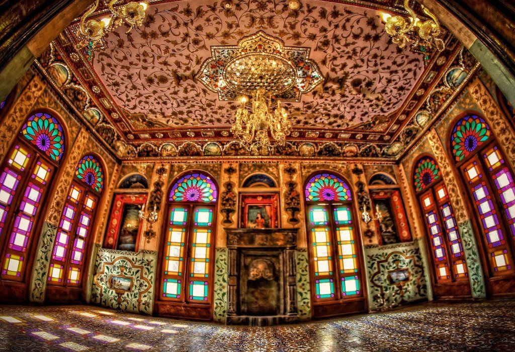
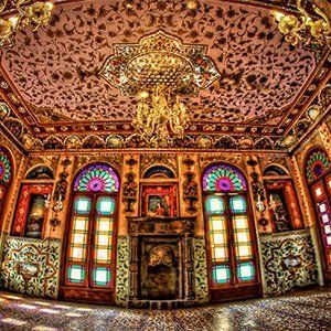
Pałac Golestan
Golestansky Palace - arcydzieło Qajar epoki urzeczywistnia udaną integrację wczesnych perskich rzemiosła i architektury z zachodnich wpływów. Ściany pałacu, jedna z najstarszych grup budynków w Teheranie, stał się siedzibą rodziny rządowej Qajar, który doszedł do władzy w 1779 roku i wykonana stolicę kraju, Teheran. Zbudowany wokół ogrodem z basenami, jak również powierzchni obsadzonej, najbardziej charakterystycznych cech pałacu i bogatej dekoracji XIX wieku. To stało się centrum sztuki i architektury Qajar, z których jest on znakomitym przykładem i jest nadal źródłem inspiracji dla irańskich artystów i architektów. Jest to nowy styl, który obejmuje tradycyjną sztukę perską i rzemiosła oraz elementy architektury i technologii 18 wieku.
Miejsce dziedzictwa światowego UNESCO | 2012
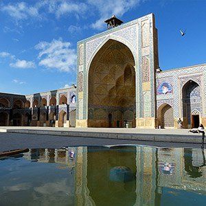
Jameh Mosque of Isfahan
Lokalizacja może być uważana za niesamowitą ilustracją ewolucji architektury Meczet do dwunastu wieków w historycznym centrum Isfahan
Masjid Yam ( „Meczet Piątkowy”), począwszy od 841. Jest to najstarszy zachowany budynek w swoim rodzaju w Iranie i prototyp późniejszych meczetów w Azji Środkowej , Złożony powierzchni 20.000 m2, jest również pierwszym islamski budynku, którego układ dostosowany Sasanidów pałac cztery jardów do religii islamskiej architektury. Jej kopuły żebrowe składane są innowacje architektoniczne, które zainspirowało budowniczych w całym regionie. Strona zawiera również wielkie przedmioty dekoracyjne, reprezentujący stylistyczną rozwój więcej niż tysiąc lat sztuki islamskiej.
Miejsce dziedzictwa światowego UNESCO | 1979
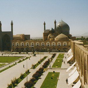
Plac Naksz-e Dżahan, Isfahan
Zbudowany przez szacha Abbasa I Wielkiego na początku 17 wieku i otoczony ze wszystkich stron przez monumentalne budynki połączone szereg dwukondygnacyjne arkady, ta strona jest znany Royal Meczet meczetów Sheikh Lotfolla, wspaniały portyk Kaysar i Timurid pałacu 15 wieku. Są to imponujące świadectwo poziomu życia społecznego i kulturalnego w Persji w Safavid ery
Miejsce dziedzictwa światowego UNESCO | 2004
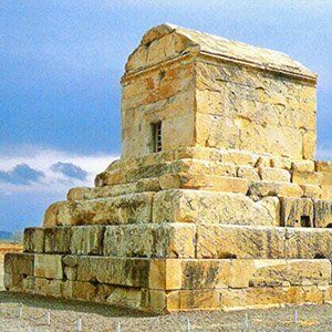
Pasargady
Pasargady był pierwszy dynastyczny stolicy imperium Achemenidów, założonej przez Cyrusa II Wielkiego, w Pars, ojczyzny Persów, w wieku VI pne. Jego pałace, ogrody i mauzoleum Cyrusa są wybitne przykłady pierwszej fazie królewskiej Achemenidów sztuki i architektury i wyjątkowych zeznań perskiej cywilizacji. Szczególnie godne uwagi pozostałości na wykresie 160 ha to Mausoleum Cyrus II; Tall-e Takht, obwarowany taras; I królewskim zespołem strażników, pokój dla widzów, pałac mieszkalnych i ogrodów. Pasargady był stolicą pierwszego wielkiego imperium wielokulturowego w Zachodniej Azji. Otaczający wschodniej części Morza Śródziemnego i Egipt do rzeki Hindusów, jest uważany za pierwszego imperium, które szanuje różnorodność kulturową różnych narodów. Znalazło to odzwierciedlenie w architekturze Achemenidów, syntetyczne przedstawienie różnych kultur .
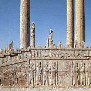
Miejsce dziedzictwa światowego UNESCO | 1979
Persepolis
Założona przez Dariusza I w 518 pne, Persepolis było stolicą imperium Achemenidów. Został zbudowany na ogromnym pół-sztucznych, pół-naturalnym tarasie, gdzie król królów stworzył imponujący kompleks pałacowy inspirowany modelami mezopotamskimi. Znaczenie i jakość monumentalnych ruin sprawiają, że wyjątkowy zabytek archeologiczny.
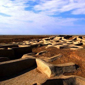
Miejsce dziedzictwa światowego UNESCO | 2014
Shahr-i Sokhta
Shahr-i Sokhta, meaning ‘Burnt City’, is located at the junction of Bronze Age trade routes crossing the Iranian plateau. The remains of the mudbrick city represent the emergence of the first complex societies in eastern Iran. Founded around 3200 BC, it was populated during four main periods up to 1800 BC, during which time there developed several distinct areas within the city: those where monuments were built, and separate quarters for housing, burial and manufacture. Diversions in water courses and climate change led to the eventual abandonment of the city in the early second millennium. The structures, burial grounds and large number of significant artefacts unearthed there, and their well-preserved state due to the dry desert climate, make this site a rich source of information regarding the emergence of complex societies and contacts between them in the third millennium BC.
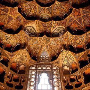
Miejsce dziedzictwa światowego UNESCO | 2010
Sheikh Safi al-din Khānegāh & Shrine Ensemble
Built between the beginning of the 16th century and the end of the 18th century, this place of spiritual retreat in the Sufi tradition uses Iranian traditional architectural forms to maximize use of available space to accommodate a variety of functions (including a library, a mosque, a school, mausolea, a cistern, a hospital, kitchens, a bakery, and some offices). It incorporates a route to reach the shrine of the Sheikh divided into seven segments, which mirror the seven stages of Sufi mysticism, separated by eight gates, which represent the eight attitudes of Sufism. The ensemble includes well-preserved and richly ornamented facades and interiors, with a remarkable collection of antique artifacts. It constitutes a rare ensemble of elements of medieval Islamic architecture.
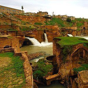
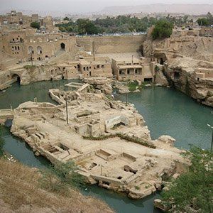
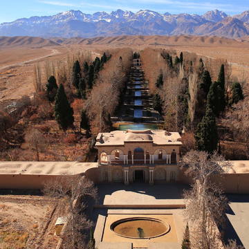
Miejsce dziedzictwa światowego UNESCO | 2009
Shushtar Historical Hydraulic System
Shushtar, Historical Hydraulic System, inscribed as a masterpiece of creative genius, can be traced back to Darius the Great in the 5th century B.C. It involved the creation of two main diversion canals on the river Kârun one of which, Gargar canal, is still in use providing water to the city of Shushtar via a series of tunnels that supply water to mills. It forms a spectacular cliff from which water cascades into a downstream basin. It then enters the plain situated south of the city where it has enabled the planting of orchards and farming over an area of 40,000 ha. known as Mianâb (Paradise). The property has an ensemble of remarkable sites including the Salâsel Castle, the operation centre of the entire hydraulic system, the tower where the water level is measured, damns, bridges, basins and mills. It bears witness to the know-how of the Elamites and Mesopotamians as well as more recent Nabatean expertise and Roman building influence.
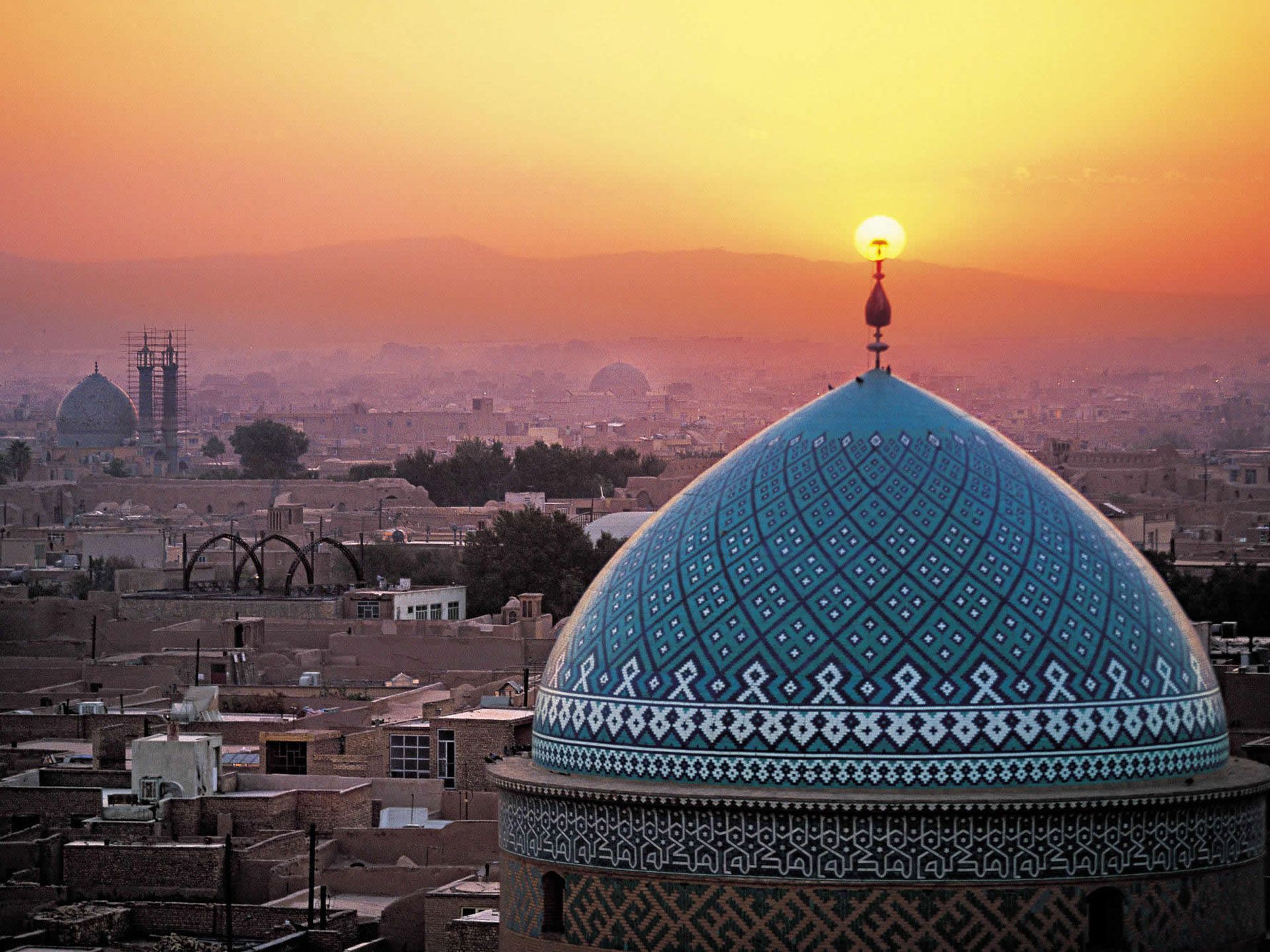
Miejsce dziedzictwa światowego UNESCO | 2005
Soltaniyeh
The mausoleum of Oljaytu was constructed in 1302–12 in the city of Soltaniyeh, the capital of the Ilkhanid dynasty, which was founded by the Mongols. Situated in the province of Zanjan, Soltaniyeh is one of the outstanding examples of the achievements of Persian architecture and a key monument in the development of its Islamic architecture. The octagonal building is crowned with a 50 m tall dome covered in turquoise-blue faience and surrounded by eight slender minarets. It is the earliest existing example of the double-shelled dome in Iran. The mausoleum’s interior decoration is also outstanding and scholars such as A.U. Pope have described the building as ‘anticipating the Taj Mahal’.
Miejsce dziedzictwa światowego UNESCO | 2015
Susa
Located in the south-west of Iran, in the lower Zagros Mountains, the property encompasses a group of archaeological mounds rising on the eastern side of the Shavur River, as well as Ardeshir’s palace, on the opposite bank of the river. The excavated architectural monuments include administrative, residential and palatial structures. Susa contains several layers of superimposed urban settlements in a continuous succession from the late 5th millennium BCE until the 13thcentury CE. The site bears exceptional testimony to the Elamite, Persian and Parthian cultural traditions, which have largely disappeared.
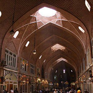
Miejsce dziedzictwa światowego UNESCO | 2010
Tabriz Historic Bazaar Complex
Tabriz
has been a place of cultural exchange since antiquity and its historic bazaar complex is one of the most important commercial centers on the Silk Road. Tabriz Historic Bazaar Complex consists of a series of interconnected, covered, brick structures, buildings, and enclosed spaces for different functions. Tabriz and its Bazaar were already prosperous and famous in the 13th century, when the town, in the province of Eastern Azerbaijan, became the capital city of the Safavid kingdom. The city lost its status as capital in the 16th century, but remained important as a commercial hub until the end of the 18th century, with the expansion of Ottoman power. It is one of the most complete examples of the traditional commercial and cultural system of Iran.
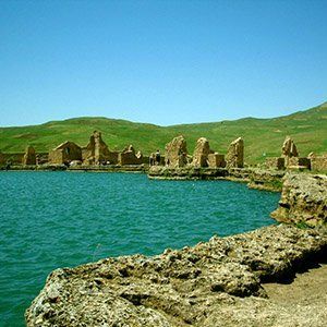
Miejsce dziedzictwa światowego UNESCO | 2003
Takht-e Soleyman
The archaeological site of Takht-e Soleyman, in north-western Iran, is situated in a valley set in a volcanic mountain region. The site includes the principal Zoroastrian sanctuary partly rebuilt in the Ilkhanid (Mongol) period (13th century) as well as a temple of the Sasanian period (6th and 7th centuries) dedicated to Anahita. The site has important symbolic significance. The designs of the fire temple, the palace and the general layout have strongly influenced the development of Islamic architecture.
Miejsce dziedzictwa światowego UNESCO | 1979
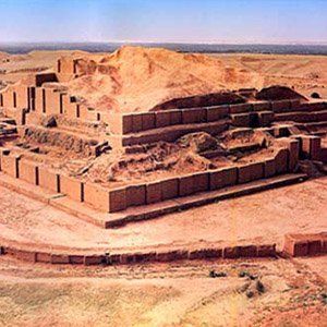
Tchogha Zanbil
The ruins of the holy city of the Kingdom of Elam, surrounded by three huge concentric walls, are found at Tchogha Zanbil. Founded c. 1250 B.C., the city remained unfinished after it was invaded by Ashurbanipal, as shown by the thousands of unused bricks left at the site.
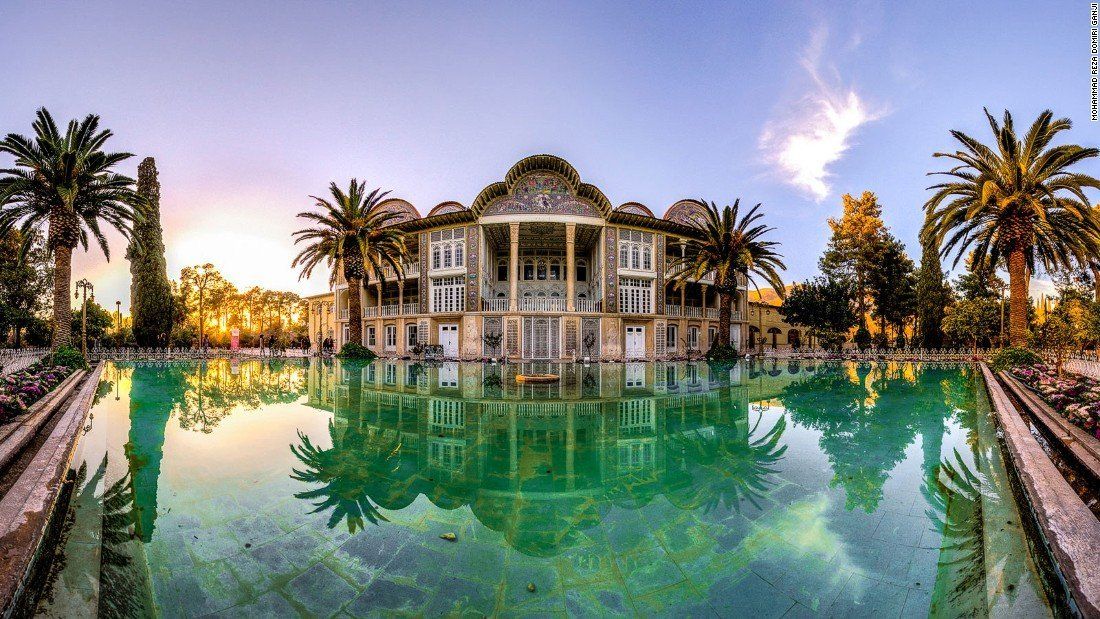
Miejsce dziedzictwa światowego UNESCO | 2011
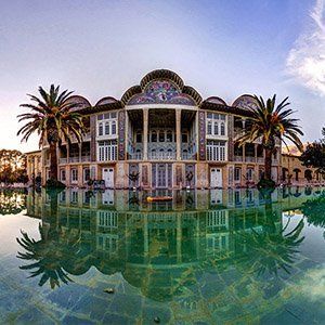
The Persian Garden(Eram Garden)
The property includes nine gardens in as many provinces. They exemplify the diversity of Persian garden designs that evolved and adapted to different climate conditions while retaining principles that have their roots in the times of Cyrus the Great, 6th century BC. Always divided into four sectors, with water playing an important role for both irrigation and ornamentation, the Persian garden was conceived to symbolize Eden and the four Zoroastrian elements of sky, earth, water and plants. These gardens, dating back to different periods since the 6th century BC, also feature buildings, pavilions and walls, as well as sophisticated irrigation systems. They have influenced the art of garden design as far as India and Spain.
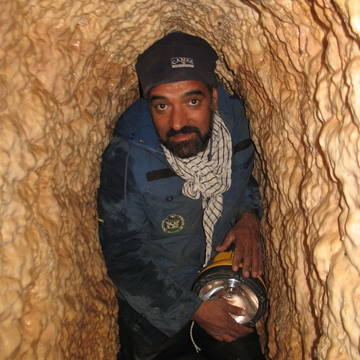
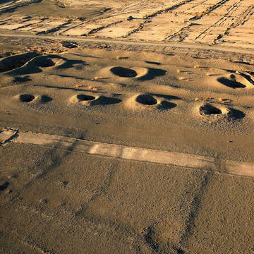
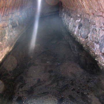
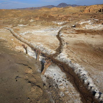
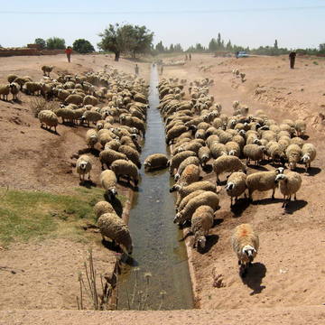
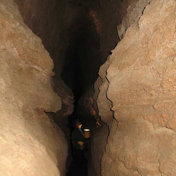
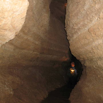
Miejsce dziedzictwa światowego UNESCO | 2016
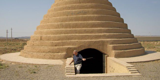
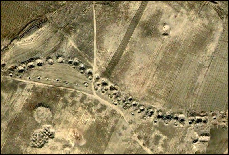
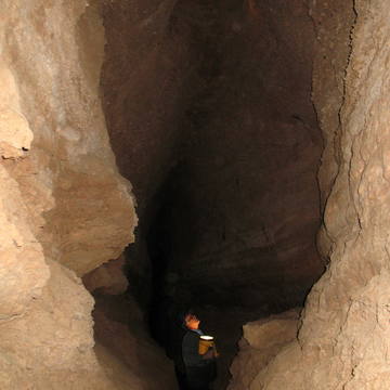
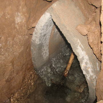
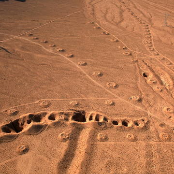
Iranian Qanat
Throughout the arid regions of Iran, agricultural and permanent settlements are supported by the ancient qanat system of tapping alluvial aquifers at the heads of valleys and conducting the water along underground tunnels by gravity, often over many kilometres. The eleven qanats representing this system include rest areas for workers, water reservoirs and watermills. The traditional communal management system still in place allows equitable and sustainable water sharing and distribution. The qanats provide exceptional testimony to cultural traditions and civilizations in desert areas with an arid climate.
The qanat system consists of underground channels that convey water from aquifers in highlands to the surface at lower levels by gravity. The qanat works of Iran were built on a scale that rivaled the great aqueducts of the Roman Empire. Whereas the Roman aqueducts now are only a historical curiosity, the Iranian system is still in use after 3,000 years and has continually been expanded. There are some 22,000 qanat units in Iran, comprising more than 170,000 miles of underground channels. The system supplies 75 percent of all the water used in that country, providing water not only for irrigation but also for house-hold consumption. Until recently (before the building of the Karaj Dam) the million inhabitants of the city of Tehran depended on a qanat system tapping the foothills of the Elburz Mountains for their entire water supply.

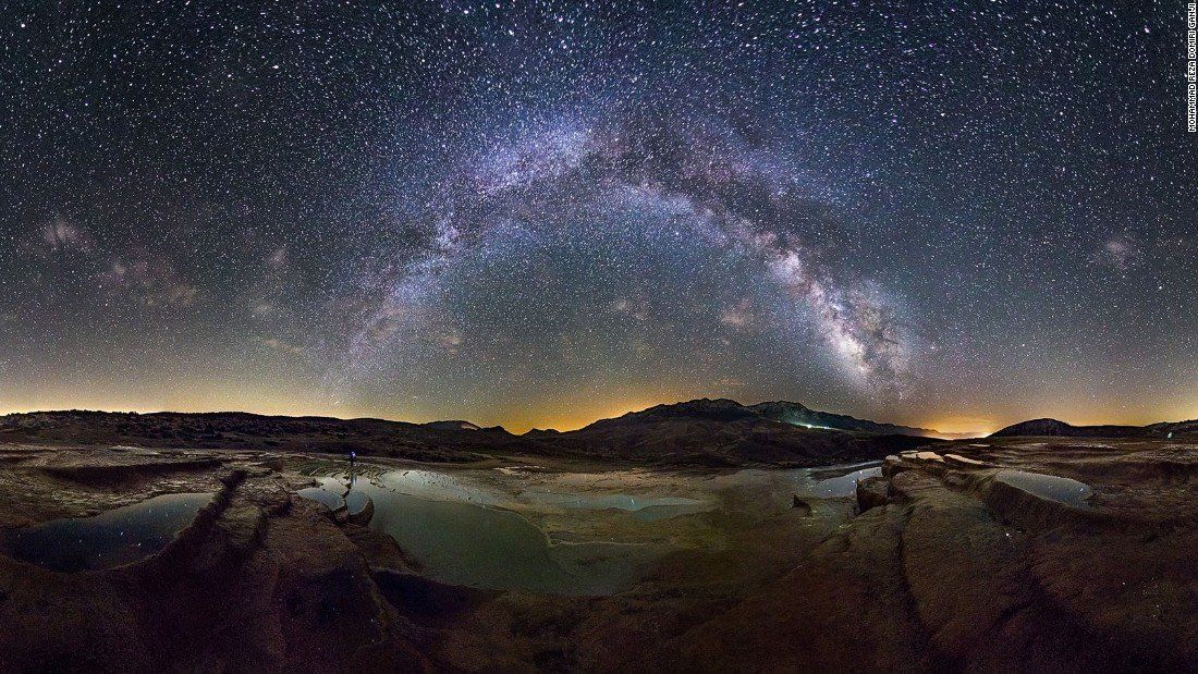
Miejsce dziedzictwa światowego UNESCO | 2016
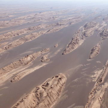
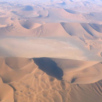
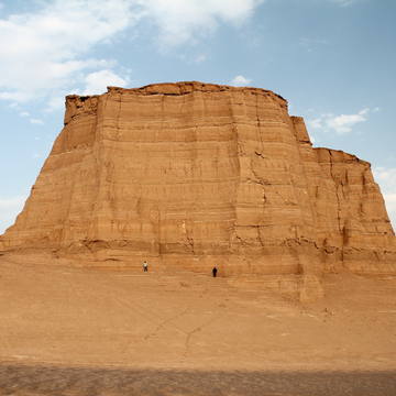
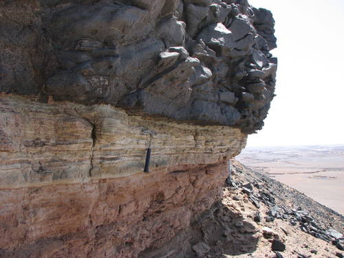
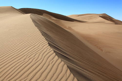
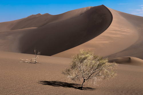
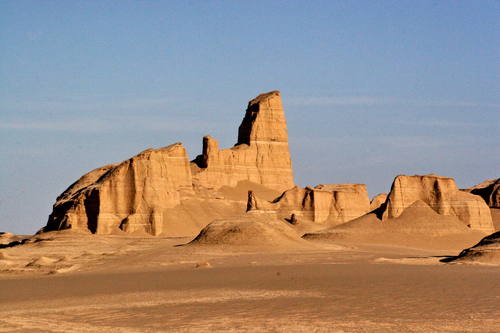
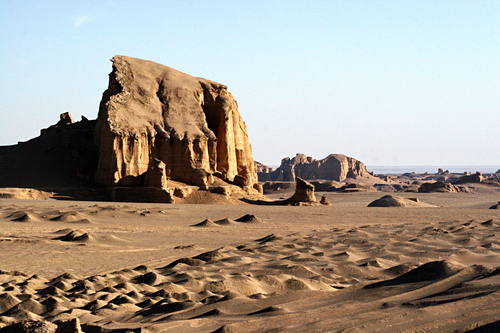
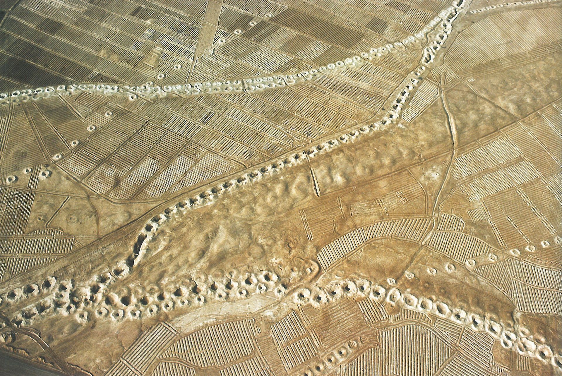
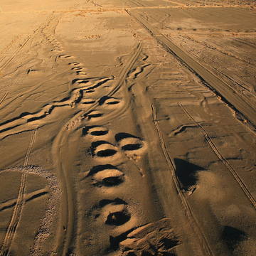
Lut Desert
The Lut Desert, or Dasht-e-Lut, is located in the south-east of the country. Between June and October, this arid subtropical area is swept by strong winds, which transport sediment and cause aeolian erosion on a colossal scale. Consequently, the site presents some of the most spectacular examples of aeolian yardang landforms (massive corrugated ridges). It also contains extensive stony deserts and dune fields. The property represents an exceptional example of ongoing geological processes.
In five of the seven years—2004, 2005, 2006, 2007, and 2009—the highest surface temperature on Earth was found in the Lut Desert. The single highest LST recorded in any year, in any region, occurred there in 2005, when MODIS recorded a temperature of 70.7°C (159.3°F)—more than 12°C (22°F) warmer than the official air temperature record from Libya.